Contemplating a third nuclear test in North Korea
By Frank V. Pabian, Siegfried S. Hecker | August 6, 2012

Shortly after its failed April 13 rocket launch, North Korea was widely expected to conduct its third underground nuclear test. Such a test would have fit the pattern of the first two nuclear tests, both of which followed failed rocket launches and international condemnation. And Pyongyang has compelling technical, military, and political reasons to conduct a third nuclear test that would demonstrate it can miniaturize nuclear warheads to fit on a missile, making its nuclear arsenal more threatening.
We believe the first two North Korean tests used plutonium as the fissile material. Without at least one more successful plutonium test, it is unlikely that Pyongyang could have confidence in a miniaturized plutonium design. The country has a very small plutonium stockpile, sufficient for only four to eight bombs, but it may be willing to sacrifice some material to gain additional data to augment information already obtained from the previous two tests.
All the same, it appears that plutonium is a dead end for Pyongyang’s nuclear arsenal because it shut down and has not restarted its five megawatt electric plutonium production reactor. Although we have seen no direct evidence of a highly enriched uranium (HEU) production program in North Korea, judging from the available evidence, we think the next bomb test will be based on HEU, or multiple bombs will be tested simultaneously, using both HEU and plutonium.
Whether and when North Korea conducts another nuclear test will depend on how high a political cost Pyongyang is willing to bear. Beijing has continued to expand aid and trade with North Korea, but has also applied significant diplomatic pressure on Pyongyang not to test. Moscow recently forgave nearly $11 billion in North Korean debt, signed a new border treaty, and is still in the game for building a gas pipeline going through the North to South Korea, but Russia is also on record as opposing continued nuclear testing. In addition, North Korea’s new supreme leader, Kim Jong-un, has shown signs of striking off in his own direction, possibly putting rehabilitation of the civilian economy ahead of enhanced military strength.
Even so, and although Pyongyang announced in June that it has no plans to test at this time, we cannot rule out the possibility that the technological and military benefits may sway Pyongyang to test again. Satellite imagery shows significant new activity at what has been identified as a likely third nuclear testing tunnel, and we find it important to re-examine North Korea’s past nuclear tests to learn about its future nuclear test capabilities.
North Korea’s previous nuclear tests. The seismic signal of North Korea’s first underground nuclear test, which took place on October 9, 2006, had a teleseismic body wave magnitude (the most common scale used for measuring the strength of seismic events from a distance) of 4.3. Using analytic methods based on arrival times of seismic waves at monitoring stations outside of North Korea, the location of the event was determined to be a highlands area north of the village of Punggye-ri, in North Hamgyong Province, in the northeastern corner of the country. While it has been reported that the North Koreans were expecting an effective yield of 4 kilotons, estimates on the explosion yield of that test generally fall below 1 kiloton.
The second test, with a magnitude of 4.7, occurred on May 25, 2009 in the immediate vicinity of the first. Despite Korean Central News Agency reports that the device yield was “Hiroshima sized” — that is, on the order of 12 to 20 kilotons — an official US intelligence estimate placed the yield as low as “roughly two kilotons.” A 2011 estimate by Los Alamos National Laboratory researchers, incorporating available seismic data and known geology but using a different analytic model, placed the minimal effective yield of the second test at about 5.7 kilotons. The authors added that further refinement of this estimate would require a more realistic topography profile of the test area.
A recent National Research Council report on nuclear testing points out that such discrepancies are not uncommon because no single relationship exists between teleseismic body wave magnitude and the yield of a nuclear test. Referring to the two North Korean tests, the report concludes that the relative locations and the ratio of their yields can be determined more accurately than their absolute locations and absolute yields. And since the seismic waveforms of the two tests are similar, the yield of the 2009 test should be scaled up by a factor of 4 to 6 from the roughly one kiloton of the 2006 test.
Locating the epicenter of a nuclear test with high confidence to within less than a few kilometers in a little-known geologic area not previously used for nuclear testing is very difficult because of insufficient information about specific subsurface geology and its potential effects on the precise timing of the transmission of regional and teleseismic signals. As the National Research Council report points out, however, if multiple nuclear tests occur in the same region, then relative methods of detection, location, discrimination, and yield estimation can be brought to bear.
Once an initial near-surface event has been recorded, all successive nearby seismic events can be fixed relative to the first recorded event in terms of direction and distance through comparison of the various arrival times at seismic monitoring stations. It is beneficial if a large number of seismic stations, including some in close proximity, monitor a test. Only 22 seismic stations of the Comprehensive Test Ban Treaty Organization’s International Monitoring System network registered the 2006 nuclear test, but 18 more stations were online to help register the larger 2009 event. In the immediate region, seven seismic stations in Japan, one in China, and one in South Korea recorded that latter test.
In 2010, researcher John R. Murphy and colleagues at the Science Applications International Corporation used recorded regional and teleseismic data from the International Monitoring System to locate the 2006 and 2009 North Korean underground tests relative to one another. Their method provides the precise “relative” location of the two tests, but does not necessarily fix either one accurately in its real-world, “absolute” location. They integrated these locations with topographic data and satellite imagery to define what they considered reasonable and accurate absolute locations for the two tests. In 2011, these researchers revised their estimates by moving the relative location plot about 720 meters to the south-southeast as shown in Figure 1.
Figure 1: A relative location plot by Murphy et al. (2011), showing revised geo-positioning of the 2006 and 2009 nuclear test epicenters as overlain by the current authors with annotations on Google Earth. The only “adit” (portal) shown on the Murphy et al. (2011) relative location plot is in the west portal area (shown as a tan square on the original plot). Murphy et al. (2011) determined the blue-hatched area to represent “candidate locations based on topographic analysis of the containment depth requirements, relative epicenter locations, and the newly derived relative depth estimate.”
(Source: Murphy J R, et al. (2011))
Early in 2010, Stony Brook University seismologist Lianxing Wen and his colleague Hui Long reported an alternative interpretation. They employed commercial satellite imagery, including a Google Earth two-dimensional map overlain with a quite similar, but independently developed, relative location plot. With this technique, they pinpointed the epicenters of the 2006 and 2009 explosions at about 1.5 kilometers to the east and northeast of the locations determined by Murphy and his colleagues.
These earlier attempts to locate the sites of North Korea’s 2006 and 2009 nuclear tests were commendable in terms of plotting relative positions of the respective epicenters. When we laid these earlier epicenter location estimates onto Google Earth imagery, however, we found that they did not match typical tunnel engineering practices for nuclear testing, which attempt to maximize the rise of terrain above the tunnel (hence providing the greatest burial depth) while minimizing the length of horizontal drilling into a mountain that is required. Also, these earlier location estimates failed to explicitly recognize that there were two portals, or starting points for tunneling, despite evidence derived from available commercial satellite imagery that the 2006 test had most likely occurred through the use of the east portal.
By correlating the available overhead imagery, known tunneling practices (particularly those used by the Pakistani nuclear program, which has been accused of aiding North Korea’s efforts), and previous seismic analysis and reporting, we were able to make geo-location estimates for the 2006 and 2009 tests that we believe are more accurate than earlier efforts. Using these new geo-locations, we believe we have provided a basis for narrowing the wide disparity in estimates of the strength of the 2009 test explosion (by narrowing the range for what is known as the depth of burial). And the methodologies we applied to the earlier tests also provide a basis for determining the likely effective length and direction of a new tunnel that appears nearly ready to host a third North Korean nuclear test — or perhaps simultaneous tests of more than one weapon design.
These test preparations — and circumstantial evidence that Pyongyang may be interested in testing both highly enriched uranium and plutonium devices — make clear that continued political pressure from the United States, China, and other interested regional powers is vital if North Korea is to be deterred from a dangerous refinement of its nuclear capabilities.
A new approach. In making our new estimates, we synthesized the information we considered consistent from the studies cited above and positioned the resultant plot on Google Earth. These superimpositions show that the 2006 event had to have been supported solely through the use of the east portal, from which a tunnel can only trend eastward, or, as was likely the case to achieve greater burial depth, northeastward. Likewise, the 2009 test would then have been uniquely supported by a tunnel beginning at the west portal, which commercial satellite imagery shows can only trend northward. Our geo-positioning was further constrained by the divergent ridgeline topography above both portals, to achieve maximum overburden with minimum tunneling (see Figure 2). The topography is best visualized in a three-dimensional context, as shown in Figure 3.
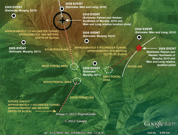
Figure 2: The authors’ repositioning of a synthesized Murphy et al. (2010) relative location plot of the 2006 and 2009 epicenters on Google Earth provides maximum rise over run vis-à-vis the east and west portals, as constrained by the local topography. The authors incorporated additional data from Murphy et al. (2011) and Wen and Long (2010) (see text). The authors also point out the likely location of a possible next test.
(Sources: Murphy J R, et al. (2010); Wen and Long (2010))
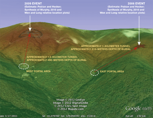
Figure 3: A 3-D Google Earth perspective of a synthesized Murphy et al. (2010) relative location plot of the 2006 and 2009 epicenters. The authors incorporated additional data from Murphy et al. (2011) and Wen and Long (2010) (see text).
(Sources: Murphy J R, et al. (2010); Murphy J R, et al. (2011); Wen and Long (2010))
Although we cannot presume an absolute geographic accuracy or precision for our epicenter locations that is better than that of the relative location plots from which they were derived (i.e., to within a few hundred meters), and being cognizant of the various potential horizontal positional errors (e.g., up to 100 meters) that can arise using Google Earth satellite imagery, particularly when imagery is draped over steep terrain, we nonetheless are confident that our estimates are the best to date. We have determined that the absolute locations are most likely constrained along narrow bands that parallel the ridgelines and afford the maximum topographic relief above each tunnel portal. Our resulting best estimates are that the 2006 test epicenter is located near 41.2849 degrees north latitude and 129.1084 degrees east longitude, and the 2009 test epicenter is near 41.2914 degrees north latitude and 129.0819 degrees east longitude (as derived from Google Earth and its displayed October 8, 2009 commercial satellite imagery). The effective lengths of the tunnels from the east and west portals to the epicenters are approximately 1.0 and 1.2 kilometers, respectively, or roughly equivalent to what Pakistan reported for its May 1998 tests. But tunnel length is just one of a number of similarities we found between Pakistani and North Korean nuclear testing tunnel design.
Possible North Korea–Pakistan nuclear testing connections. North Korea and Pakistan have a long history of cooperation in the nuclear arena. North Korea sold missile technologies and manufacturing know-how to Pakistan in the 1990s. Pakistan sold centrifuge technology to North Korea and provided training for North Korean specialists at its Khan Research Laboratories. Although there have been numerous reports of North Korean–Pakistani exchange in weapons designs and nuclear testing, no definitive proof has surfaced to date. Both countries have publicized their nuclear test successes, however, and, in the process, provided surprising details that suggest some similarities in test containment practices.
The Pakistani government allowed the release of remarkably detailed information about the five nuclear tests it carried out simultaneously in one tunnel in the Ras Koh Hills on May 28, 1998. The Pakistani test experience was widely publicized, both by nuclear scientists and the news media in books and articles; the publicity included videos showing the test site, during and post-test. A. Q. Khan, often called the father of Pakistan’s nuclear program, claimed that the tests involved one large and four “low-yield” tests. Samar Mubarakmand, who was in charge of the Pakistani Atomic Energy Commission’s super-secretive Directorate of Technical Development, claimed that the test tunnel, rather than being straight, was “designed in the form [of] a double-S shape,” while a Pakistani Defence Journal article repeated an earlier claim that the tunnel had a “fishhook” at the end to allow for a device emplacement that would result in the tunnel self-sealing after the detonation. Another report also claimed that the tunnel was “M” shaped, suggesting that the tunnel may have also bifurcated near the end to allow for the single large test to be emplaced in one fishhook, with the set of four smaller ones possibly at a second fishhook.
The 2006 North Korean nuclear test was only partially successful and caused radioactive debris to seep from the test site; some of that debris was detected by American air sampling systems in the region. Pyongyang provided no additional details, except to hint that the device used two kilograms of plutonium, an unrealistic number, considering that the Nagasaki bomb contained six kilograms.
On September 8, 2010, Pyongyang Korean Central Television broadcast a partially animated dramatization of the 2009 test. Several of the graphics from that video have surfaced in the open literature, including the alleged layout of the test tunnel shown in Figure 4. The video appears to be a propaganda piece, intended to impress its citizens, to inform the international community of the great precautions North Korea claims to have taken to prevent radiation leaks from the test, and to help convince doubters that the explosion was indeed a nuclear test. Clearly, some aspects of this video have no basis in fact, e.g., the massive arched portal door shown in the animation bears no resemblance whatsoever to the 2009 test portal area’s hamlet-like appearance, which can be observed on commercial satellite imagery. In addition, the video shows a topographical map of what is presumed to be the test epicenter and seismic monitoring stations, but the mountain contours do not match the Punggye-ri site.
The tunnel layout shown in Figure 4 does, however, appear to have similarities to the described Pakistani tunnel at Ras Koh. It includes several flat S-shape and zigzag features, and a loop-around hook (e.g., “fishhook”) leading to the device emplacement chamber. Unlike the Pakistani tunnel, the North Korean tunnel is alleged to contain nine remotely operated internal isolation or blast doors and what we have identified as three blast and debris traps that appear plausibly located to capture any blast debris. In contrast, the Pakistani Ras Koh Hills tunnel, in addition to the self-sealing fishhook feature, was reported to have been sealed by a mixture of sand and 6,000 bags of cement. Although the similarities we cite in some North Korean and Pakistani nuclear test practices do not constitute proof of collaboration, they give us concern that North Korea could have learned a lot from the Pakistanis.
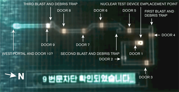
Figure 4: North Korean television animation video-frame capture depicting what was asserted to be the tunnel layout and nine interior doors for containment of the 2009 nuclear test in North Korea, along with three blast and debris traps and a fishhook-like emplacement chamber (annotations in white were added by the authors).
(Source: Screen capture from fourth episode of North Korean serialized drama called “Country That I Saw”, as broadcast from Korean Central Television, Pyongyang, via Satellite in Korean. The episode aired in September 2010. Yonhap News, Seoul, provided permission to use this image.)
Revisiting yield estimates for the 2009 test. Initial yield estimates of the 2009 test ranged from roughly 2 to 6 kilotons, but were generally viewed to be less than 4 kilotons. Two recent studies, one by researchers from the Lawrence Livermore National Laboratory and one by Los Alamos National Laboratory researchers, have resulted in greater uncertainties in yield estimates. The Lawrence Livermore researchers concluded that the explosive yield was no more than 2 kilotons if the test were carried out at a depth of burial between 100 and 500 meters; the Los Alamos researchers concluded that explosive yield scales with depth of burial, potentially leading to a calculation of explosive yield of as much as 7 kilotons. Using two Los Alamos scaling models that relate to the depth of burial of a test site and our own Google Earth-based calculations for burial depth, we were able to derive somewhat more refined yield estimates. With our calculated burial depth of 490 meters, the yield estimate varies from 4.0 up to about 6.9 kilotons for the 2009 test, depending on which of the two scaling models is applied. A re-evaluation of the 2006 effective yield using similar methodology indicates that the yield was about 1.0 kiloton. These findings are consistent with National Research Council reporting on the general comparison of waveforms for the second test as falling within a range of four to six times that of the first.
Is Pyongyang preparing another test? North Korea appears to have an underground tunnel ready for testing. Commercial satellite imagery shows a recently excavated “south portal” for a tunnel in Punggye-ri, situated very close to the tunnels for the first two tests. It apparently has been under construction since 2009 and significant activity was reported at the tunnel site after the failed April space launch. Technically, North Korea could be ready to test within two weeks.
Earlier reports mention the appearance and disappearance of additional heaps of earth and sand in the area near the south portal entrance, allegedly part of an effort to entomb a nuclear test device or devices and suggesting that a test would have come within two weeks; we and others have not been able to confirm those reports based on currently available commercial satellite imagery. Activity can be observed on the tailings spoil pile, involving what appears to be a small train of mining carts. These carts are likely to have been used to move excavated rock during tunnel mining and construction but could also be involved in ongoing or future test preparations once the tunnel is complete, which it is now assessed to be.
If North Korea follows standard nuclear test-engineering practices, potentially also based on Pakistani practice, it would be reasonable to assume that this new test tunnel might be roughly one kilometer long. Beginning at the south portal, a one-kilometer line (as measured by the Google Earth ruler tool) in the direction of maximum possible overburden produces the interesting layout shown in Figure 5. Such a tunnel, excavated in a southwestern direction from the south portal, provides a burial depth of about 380 meters. Using Google Earth, we predict the likely epicenter of a possible next nuclear test to be roughly 41.2687 degrees north latitude and 129.0811 degree east longitude, as shown in Figure 5.
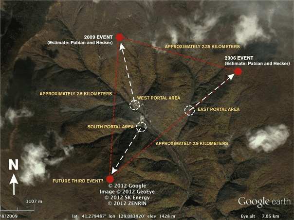
Figure 5: Derived epicenter estimates relative to a predicted epicenter location (at the end of an equivalent one-kilometer-long support tunnel from the south portal that would provide maximum rise over run).
What is Pyongyang likely to test next? No one outside of North Korea knows when, or even if, North Korea will conduct another nuclear test, and if it does, what the design and fissile material will be. The test tunnel appears ready, and it may take as little as two weeks to prepare for a test. That is the amount of time it took in 1998 for Pakistani scientists to make final preparations, once Islamabad made the political decision to test in response to India’s tests.
For the long term, the plutonium route is at a dead end for North Korea; Pyongyang decided to shut down its five megawatt reactor in 2007, and it has no other facilities for producing plutonium. At the same time, North Korea has strong technical reasons to do a third plutonium test, in spite of its meager plutonium inventory, which we estimate to be 24 to 42 kilograms, to better calibrate its computer models and understand implosion devices. It is therefore conceivable that North Korea may conduct two tests simultaneously, using a double fishhook at the end of the tunnel, with one bomb fueled by HEU and a second by plutonium. Pakistani scientists made a similar decision to conduct multiple tests simultaneously to maximize technical results. If Pyongyang has more HEU than we surmise, it may do more than one HEU test with different designs. Two detonations will yield much more technical information than one, and they will be no more damaging politically than if North Korea conducted a single test.
Serious questions remain as to whether North Korea will choose either HEU or plutonium, or both, for the next test. The evidence for North Korea possessing HEU is only circumstantial, and even if it possesses HEU, the quantities are likely not very large. In addition, plutonium has historically been chosen as superior bomb fuel for miniaturized devices.
As pointed out in a recent UN Panel of Experts Report on North Korea, Khan may have provided Pyongyang with Pakistani HEU bomb designs that could fit on North Korea’s Nodong short-range missile. If so, Pyongyang may have decided that HEU may prove to be a quick path to miniaturization and possibly allow for a fast expansion of its arsenal.
What now? North Korea has strong technical and military drivers to conduct additional nuclear tests, and it is capable of doing so within as little as two weeks. It appears that Kim Jong-un’s regime is now weighing the political costs it would have to bear should it decide to test. Pyongyang’s recent statement that it has no current plans to test and its direct denial in July of a Japanese news report claiming that Kim Jong-il had given orders to build HEU weapons are hopeful signs. Nevertheless, it is imperative for Washington, Beijing, and their partners in the six-party talks to join forces to increase the costs on North Korea of continued testing. An additional nuclear test or two would greatly increase the likelihood that Pyongyang could fashion warheads to fit at least some of its missiles — a circumstance that would vastly increase the threat its nuclear program poses to the security of Northeast Asia.
Together, we make the world safer.
The Bulletin elevates expert voices above the noise. But as an independent nonprofit organization, our operations depend on the support of readers like you. Help us continue to deliver quality journalism that holds leaders accountable. Your support of our work at any level is important. In return, we promise our coverage will be understandable, influential, vigilant, solution-oriented, and fair-minded. Together we can make a difference.
Topics: Nuclear Weapons, Opinion
Get alerts about this thread
0 Comments
Oldest

Frank V. Pabian
Pabian is senior geospatial information analyst at the Los Alamos National Laboratory. Last year, he served as a visiting fellow at the Center for... Read More

Siegfried S. Hecker
Siegfried S. Hecker is a professor of practice at the Monterey Institute of International Studies at Monterey and at the Department of Nuclear... Read More