Otis teaches a terrifying lesson in rapid hurricane intensification
By John Morales | October 27, 2023
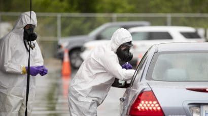
 Some of the damage in Acapulco from Hurricane Otis. Photo credit: Raquel Mendez Avalos.
This is a scary new paradigm in the tropics. And we all need to worry.
Hurricane Otis struck very near Acapulco, Mexico, on Tuesday night as a monster 165 mile-per-hour category 5 cyclone. On Monday night, about 24-hours before landfall, the National Hurricane Center (NHC) was predicting it would do so as 70 mile-per-hour tropical storm.
With the energy content (and destructive potential) of the wind increasing with the cube of the windspeed, that means that Otis reached Mexico with 13 times more destructive potential than what had been expected! Even when the hurricane warning was issued at 4 a.m. local time on Tuesday, the hurricane center was still forecasting just an ordinary category 1 hurricane to reach Mexico’s Pacific coast. For a region of Mexico that had never experienced anything stronger than a category 1, getting hit by a cat-5 with little to no warning has led to severe consequences.
I want to be clear that this is not an article about the skill of the National Hurricane Center. The collection of experts at their offices in Miami is the best in the hemisphere at analyzing and forecasting tropical cyclones. In recent years, I’ve seen them become less hesitant to forecast rapid intensification of hurricanes‚ as they correctly did for hurricanes Idalia and Lee in the Atlantic this year.
In the case of Otis, the hurricane center first noted in its Sunday advisories that the waters were “very warm.” While the statement was certainly correct, that characterization of the sea surface temperatures could be a candidate for the understatement of the year. Water temperatures across the world’s oceans aren’t just very warm. They’re record-hot. In the Pacific, short-term climatic variations like el Niño have a lot to do with the elevated surface temperatures. The phenomenon is causing readings 3 degrees Celsius warmer than average in the equatorial Pacific. Closer to the Mexican coast near Acapulco, the water was above 31 °C (88 °F) on the eve of Hurricane Otis. Generally, tropical storms only need the water to be 27 °C or warmer to support strengthening, so the hot pool of water near Mexico was premium fuel for Otis.
Rapid intensification for Otis was first contemplated late on Monday night based on the low-level structure of the tropical storm at the time. On Tuesday morning, the hurricane center indicated that models showed a 1-in-4 chance of Otis undergoing rapid intensification (RI), and by midday that chance was characterized as “greater than normal”.
But rapid intensification was never explicitly called for.
Otis then proceeded to go from a 50-mph, low-end tropical storm at 11 p.m. Monday to a 160-mph, category 5 hurricane 24 hours later. Just on Tuesday afternoon, Otis grew from a tropical storm into a category 3 hurricane in the span of 6 hours! Otis’s rapid intensification broke Hurricane Patricia’s record in 2015 for fastest-strengthening hurricane in a span of 12 hours in the eastern Pacific.
While Otis is a record-setter, this is far from the first time the eastern Pacific has seen rapidly intensifying hurricanes this year. A whopping 80 percent of this year’s storms have undergone rapid intensification. Norma did it just before Otis, and Lidia earlier this month went from 80 to 140 mph in just 18 hours. Jova, in September, went from 70 to 155 mph in a day. In the western Pacific, nearly half of all storms have gone through rapid intensification this year.
The Atlantic sea surface temperatures have also been running extra hot this year. Even now in mid-October, the water temperature is setting records, almost three-quarters of a degree Fahrenheit hotter than the previous mark. That temperature anomaly (three and a half standard deviations above the 30-year mean, for statistics mavens) means that the chance of it occurring by chance is 1-in-4.200. Weaker trade winds and less pollution have helped stoke the Atlantic marine heatwave.
The hot Atlantic Ocean has led to a much busier than normal 2023 hurricane season, with 20 tropical or subtropical storms so far; the normal number is 14. The Atlantic basin, which this year has often faced El Niño-produced wind shear, a hostile condition for fledgling tropical cyclones, still has had three hurricanes undergo rapid intensification in 2023: Franklin, Idalia (which struck Florida), and Lee, which reached the once rare category 5 intensity.
Those of you that follow developments in climate science have known for many years that the UN’s Intergovernmental Panel on Climate Change (IPCC) had been predicting that tropical cyclone intensities would increase in a warming climate. Confidence in that forecast has gone from medium to high over the years. And while the total number of tropical storms around the globe has remained steady, the proportion of those reaching category 4 and 5 intensity has indeed gone up.
What’s been happening lately cannot be sugarcoated. Since the beginning of the century, 16 category 5 hurricanes have formed in the Atlantic—a rate slightly higher than one every year-and-a-half. In contrast, from 1970 to 2000 only six systems were able to reach cat 5. That means that the frequency of category fives has tripled compared to the last three decades of the 20th century. Going back to 1924, only 6 percent of hurricanes had been able to reach that extreme strength over a century-long span.
In the battle of wind shear versus hot sea surface temperatures, it seems like the warm water is winning most of the time. Otis had wind shear that should have worked to weaken the storm, and it didn’t seem to matter.
This is a scary thought, even for a seasoned meteorologist like me.
Over my nearly four decades as a weather forecaster and TV meteorologist, my audience has come to know me as a non-alarmist. I try not to worry people when there’s no need to worry. That comes from speaking to dozens of Floridians in the months and years after category 5 Hurricane Andrew, which flattened areas south of Miami in 1992, and in hearing from hundreds of Puerto Ricans after the devastating impact of Hurricane Maria in 2017, from which they’re still struggling to recover. People that experience catastrophic category 4 and 5 hurricanes can be scarred for life. It’s an experience no one wants to go through twice. Some are left with a degree of post-traumatic stress disorder that causes them to get very anxious whenever new tropical storms form.
I look for ways to keep people from feeling weather anxiety when they don’t need to. If the storm isn’t coming, it’s not coming. And I am supremely confident in forecasting hurricane tracks.
But as the temperature of the planet increases, my confidence in forecasting storm intensity is decreasing. Today I am no longer as comfortable in putting everyone at ease in regard to the strength of a storm. I am afraid of rapid intensification cycles happening at the drop of a hat.
One of these days, there’s going to be a run-of-the-mill tropical storm in the central Bahamas that’s going to ramp up to category 4 or 5 intensity before reaching Miami a day later. Will the experts at the National Hurricane Center (or I) be able to correctly call that such rapid intensification is in the offing?
We are in a new era—one in which climate change, through the physical changes it’s producing in the ocean and atmosphere, is boosting windspeeds and rainfall in hurricanes. The insurers and reinsurers see it, and it’s reflected in their premiums. The military sees it, and it’s reflected in the actions they’re taking to retrofit bases and prepare for climate-driven crises. And three in four Americans see it, and it’s manifesting in how the climate crisis is ticking up in the rankings of the most important young voter priorities.
I want you to frame future hurricane seasons in this scary new paradigm. Future hurricanes are more likely to be worse than any we’ve ever experienced because of man-made climate change. If we don’t soon lead the way in cutting greenhouse gas emissions to slow unbridled global heating, then for sure we’re going to want to get out of the way of them.
But people keep moving to the coast, putting more businesses, homes, and lives in harm’s way, and there are clearly limits to the amount of resiliency that can be built into coastal communities. Preparedness has never been more important. Sadly, not everyone can afford to properly prepare or even move out of the way of a tropical cyclone, especially in the Global South.
Keeping global warming to an aspirational 1.5 degrees Celsius above preindustrial levels, or even 2 degrees, will go some way toward slowing or stopping this very concerning trend of increasing numbers of uber-strong tropical cyclones. And even if climate change trends can be slowed, hurricane forecasters and the populations that rely on them will still need to develop a healthier respect for—and keep a closer eye on—marginal tropical storms that just might turn into deadly monster cyclones.
Together, we make the world safer.
The Bulletin elevates expert voices above the noise. But as an independent nonprofit organization, our operations depend on the support of readers like you. Help us continue to deliver quality journalism that holds leaders accountable. Your support of our work at any level is important. In return, we promise our coverage will be understandable, influential, vigilant, solution-oriented, and fair-minded. Together we can make a difference.
Keywords: Acapulco, National Hurricane Center, Otis, hurricanes, rapid intensifcation
Topics: Climate Change

John Morales
John Morales is an atmospheric and environmental scientist and a fellow of the American Meteorological Society. He is the hurricane specialist for... Read More


Hello dear John, certainly is very scary situation, even with the new technologies implemented by national hurricane center, we will be so vulnerable to sudden changes on hurricane intensity that will put lives and properties on danger, this is the time to prepare ourselves for such dangerous changes,thanks so much for this valuable information.
Best regards Sent