Expanding the bull’s eye of solar development on public lands
By Dustin Mulvaney | April 2, 2024
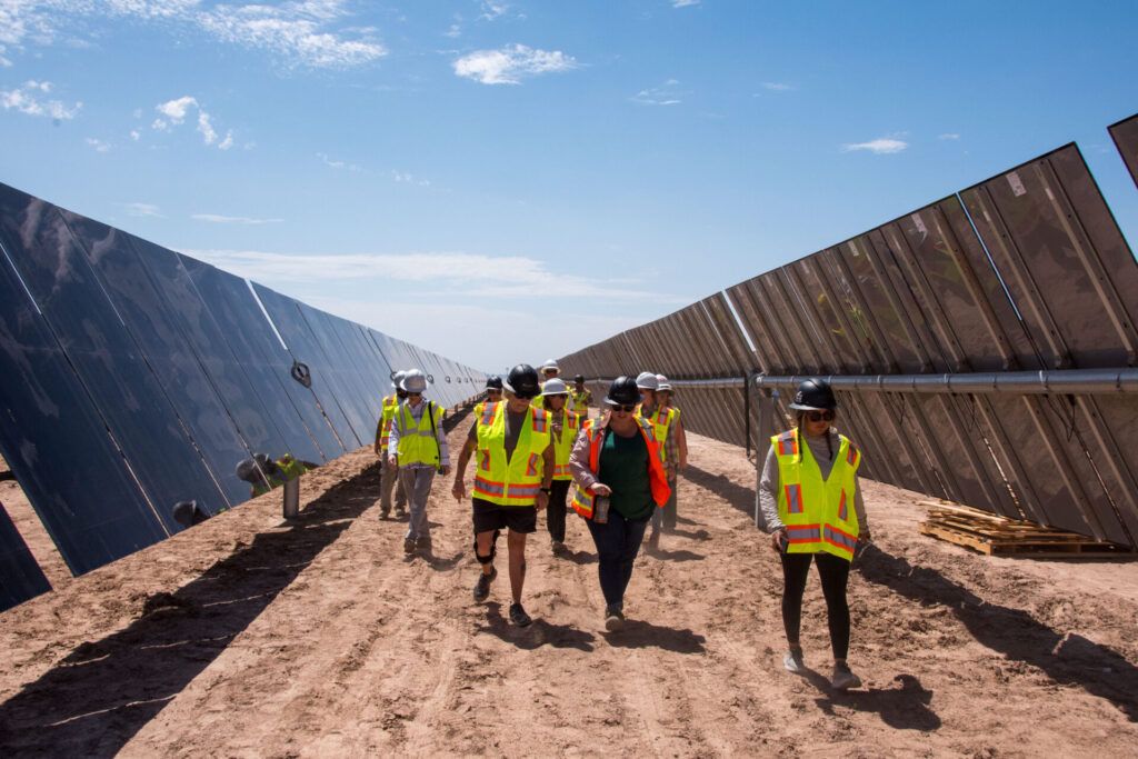 BLM Arizona visits a solar construction site on private land in August 2023. (Michelle Ailport/BLM Arizona)
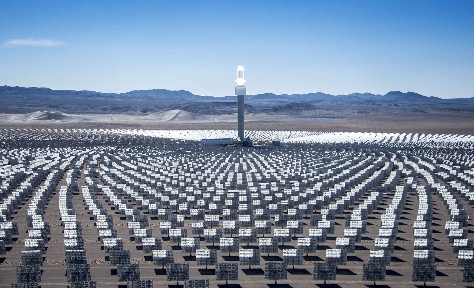
Proposed changes to the US Bureau of Land Management’s Western Solar Plan would clear the way for large solar energy projects to be built across vast tracts of public lands in 11 western states. The proposed amount of land available to the solar industry ranges between 8 acres and 55 million acres, depending on the proposed scenario (the Bureau of Land Management provides five alternatives). The agency’s preferred plan would open up 22 million acres, or 34,375 square miles, to solar development—an area roughly the size of the state of Indiana.
The federal agency estimates over the next decade solar projects could be developed on one million acres across all western public lands, an area one-and-a-half times the size of Rhode Island.
The changes are part of the Biden administration’s efforts to advance clean energy and transmission infrastructure, construct carbon pollution-free power, and increase grid resiliency to prevent power outages. The administration’s goal is to achieve a 100 percent clean electricity grid by 2035, an ambitious timeline that experts say will also increasingly create land-use conflict in the western United States as renewable energy deployment accelerates.
Solar development on public lands is controversial because these landscapes can be important to wildlife conservation and cultural resources. The Bureau of Land Management oversees expansive areas of relatively undisturbed habitat for many threatened and endangered species. The lands are important corridors for large mammal migrations, and sites can contain cultural resources or be important places of Native American tribal heritage. Solar projects can be extensive—measured in square miles—and they can cause significant land disturbance, habitat loss and fragmentation, and, for some projects, damage to cultural resources. Although the proposed update to the Western Solar Plan would keep some areas off limits due to environmental or wildlife impacts, there are very weak protections and poorly defined land classifications elsewhere that undermine conservation.
The Biden administration’s climate action goals are laudable overall, but there are reasons to be skeptical of a plan that prioritizes solar and transmission deployment in patterns that undermine conservation goals, especially when there are so many alternative places to put solar. The Bureau of Land Management’s Western Solar Plan update inverts the original intent of the planning process from one that sought to avoid wildlife and cultural resource conflict to one that prioritizes transmission developer and utility interests on these publicly owned landscapes. This abrupt shift warrants a significant revision before finalizing any new rules, if not outright rejection.
Media coverage of this issue often misconstrues opposition to solar on public lands as opposition to large-scale solar period. Framed this way, well-meaning journalists and energy pundits point to the low costs of large scale solar and how rooftops alone could not generate enough electricity to power cities and industries using the grid we have today. But this is not about large-scale solar versus rooftop solar—it’s about responsible land use for solar development. Most large-scale solar sited to date across the American West has not met opposition from environmental groups or tribes because the projects are put in areas previously developed or used for agriculture. For a meaningful and productive conversation it is critical to see these issues—opposition to use of public lands versus opposition to large-scale solar—as distinct. Solar projects on public lands are guaranteed to be impactful in the American West to habitat and ecosystems because of their legacy as being undeveloped. The US government should encourage responsible solar development first and foremost. Tradeoffs between solar development and important habitat loss should be the last resort.
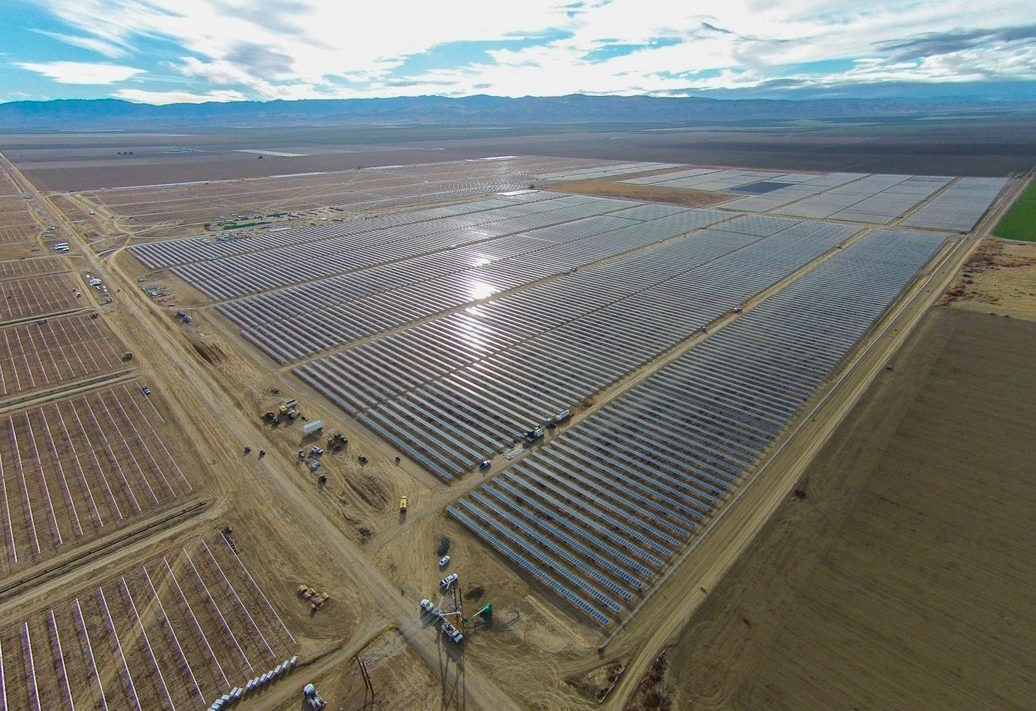
A brief history of solar power in the American West. Congress first opened public lands to solar development through the Energy Policy Act of 2005, which required the agency to permit 10 gigawatts of renewables by 2020. The Energy Act of 2020 increased that amount to 25 gigawatts by 2025 and reduced rents to solar developers by as much as 70 percent. As of March 2024, there are 41 solar projects with a total capacity of about 10 gigawatts across 74,491 acres (116 square miles) making up most the renewables on public lands sited to date. Another 26 projects totaling 19.5 gigawatts across additional 179,698 acres (281 square miles) are under active consideration. All of these projects would be grandfathered into the 2012 Western Solar Plan and unaffected by the update. If all the grandfathered projects are approved, the total acreage for the 67 projects built, under construction, or in planning on public lands would amount to 283,200 acres (443 square miles) and 35 gigawatts, 10 gigawatts more than the Congressional mandate, by the summer 2025. Many of these projects are speculative and may be withdrawn pending their estimate for cost of interconnection to the grid. Other projects could be denied by the Bureau of Land Management, something that has only happened a few times in the solar leasing program’s 15 years.
To put these acreage numbers into context, consider onshore oil and gas production today occurs on 12.6 million acres of public lands, ten times more acreage than is proposed for solar. However, the lands where oil and gas is produced, or is leased or leasable to industry, is not available for solar development. Importantly, the public lands for solar are in addition to those developed by oil and gas industries; they are located in different places and will result in impacts to different species and communities. For example, there are few oil and gas projects that impact the desert tortoise (Gopherus agassizii), whereas a large portion of solar projects on public lands require translocation of the animal because the species occupies the same lands that solar developers prize.
The oil and gas industry’s access to public lands is often used as a justification for solar development: If polluting fossil fuel companies get to use public lands, why shouldn’t clean energy companies? This misses the point that there are multiple alternatives to place large solar facilities, like abandoned and marginal agricultural land, landfills, abandoned mines, and brownfields. Adding more distributed solar and battery energy resources closer to load—meaning, closer to population centers—could help some places shut down natural gas. In fact, there are a few areas where solar projects on public lands surround natural gas power plants, including a brand new natural gas power plant approved that will be built adjacent to the Dry Lake Solar Energy Zone for NV Energy, the electric utility that serves Las Vegas.
Even more troubling, the Inflation Reduction Act tied renewable energy development on public lands to the opening of onshore oil and gas development: “The Secretary may not issue a right-of-way for wind or solar development on Federal land unless – an onshore lease sale has been held during the 120-day period ending on the date of the issuance of the right-of-way for wind or solar development.” In the agency implementation of the statute, the bureau states that, “the BLM may not issue a right-of-way for wind or solar energy development on Federal land unless it has (1) held an onshore oil and gas lease sale during the past 120 days and (2) offered the lesser of a “sum total” of either 2,000,000 acres or 50 percent of the acreage for which EOIs [expressions of interest] have been submitted for lease sales during the previous one-year period.”
In other words, further solar development on public lands will facilitate the further development of oil and gas on public lands. This impact is missing entirely from the agency’s analysis of the proposed changes. The draft plan update only describes the greenhouse gases displaced by up to 93 GW of solar electricity generation by 2045, and ignores the climate pollution from tethering solar and fossil fuel development on public lands far into the future.
The new energy rush. The initial period of solar development was a major challenge for the Bureau of Land Management. By opening up 22 million acres in 2005—first come, first served—to solar developers, the agency encouraged rampant speculation. Goldman Sachs occupied nearly 25 percent of all applications despite having no technology; similar-sized portions of applications would eventually end up with First Solar and NextEra. Other companies were blocked off by the first-come, first-served process, which overwhelmed agency staff with applications, a practice that changed with finalization of the Western Solar Plan. Because of haphazard planning, many of the lands proposed for solar projects were lands donated to the agency by the conservation group Wildlands Conservancy like the Sleeping Beauty Valley, that would eventually end up Mojave Trails National Monument. The Western Solar Plan significantly reduced these conflicts by discouraging development on these kinds of sites by excluding some of the 22 million acres from development.
The Western Solar Plan was initiated by the Secretary of the Interior Dirk Kempthorne at the end of the George W. Bush administration in 2008, but mostly developed under President Obama’s Interior Secretary, Ken Salazar, who proclaimed “we are putting a bull’s-eye on the development of solar energy on our public lands.” At the time, the Bureau of Land Management was receiving project applications and offering public lands for solar development in order to help ease the land acquisition requirements to build large-scale solar. Large-scale solar projects needed large-scale parcels to develop. Through the American Recovery and Reinvestment of 2009, the federal government was looking to invest in “shovel ready” solar projects, and proposals on public lands were eligible for fast-tracked environmental reviews. After several waves of public comment on the plan, a record of decision was signed in 2012. The Western Solar Plan would govern development on public lands across six states Arizona, California, Colorado, Nevada, New Mexico, and Utah.
The 2012 Western Solar Plan sought to reduce land use conflict by introducing 300,000 acres of public lands designated as Solar Energy Zones. These zones were intended to pre-screen for cultural and ecological resource conflicts and reduce land-use impacts. Companies seeking to develop in Solar Energy Zones were promised very light-handed environmental assessments as an incentive for locating there. However, in addition to these Solar Energy Zones, the agency identified over 20 million acres as also appropriate for solar energy development with an environmental impact statement. These so-called “variance lands” were often more valuable to solar developers because of their proximity to transmission, and as a result many Solar Energy Zones remain undeveloped or undersubscribed, with some exceptions, like the 202,000-acre Riverside East Solar Energy Zone in southeastern California. These Solar Energy Zone and variance land processes would be eliminated in the update proposed this year and replaced with a process that treats all agency administered lands with the same level of environmental review.
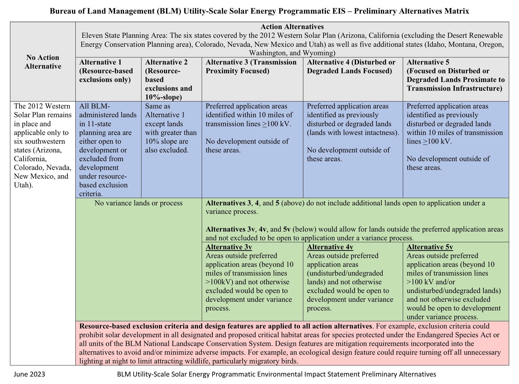
Changes on the horizon. The Western Solar Plan update will expand the eligible areas for solar development to 11 states. The agency has provided five alternative rule changes, all of which have resource-based exclusions that keep many of the most important conservation areas off limits to development, including Areas of Critical Concern and critical habitat for federally-listed endangered species. The greater sage grouse, for example, is not listed as endangered under the federal Endangered Species Act, although US Fish and Wildlife Service found in 2010 that its listing as threatened was “warranted, but precluded” by other species of higher conservation priority.[1] But the sage grouse is subject to a memorandum of understanding between the BLM, Forest Service, and stakeholders, and consequently has special protections under the proposed Western Solar Plan.
But there are only very limited protections for other species, like the Mojave desert tortoise, Although the desert tortoise is under consideration to be uplisted as endangered under California’s Endangered Species Act, it is only considered “threatened” under the federal Endangered Species Act, in spite of the fact the species has lost 90 percent of its population since 1970. Resource exclusion for desert tortoises will be limited to areas that receive translocated tortoises from other solar projects and real estate developments. Ironically, as vice president, Joe Biden once singled out a desert tortoise website aimed at educating the public about the species as “government waste;” now, as president, he could sign off on a plan that will further imperil the species.
The first alternative proposed by the agency would most drastically increase the available land for solar because it removes a slope constraint. The 55 million acres of land available in this scenario is about the size of Utah. The initial solar development program developed in 2005 excluded all areas with a slope great than 10 percent, because it was thought this land would not be viable for large solar facilities, which at the time were mostly a different technology, concentrated solar power projects, not photovoltaics. The second alternative is nearly the same as the first but retains the restriction to lands with less than a 10 percent slope.
The agency’s preferred rule change (the third alternative) opens up 22 million acres of “transmission proximity focused” lands, and would give priority to solar projects sited within 10 miles of existing or planned transmission. This is an about face from the spirit of the plan, which sought to prioritize low-conflict lands, to one where developers and utilities set the priorities. Following the pathways of transmission is bound to create significant cumulative effects to wildlife migration by habitat fragmentation, especially as the plan expands further into bighorn sheep territory in areas of southern California and moves north into conflict with pronghorn antelope and elk migration corridors.
The fourth and fifth alternatives focus on what the agency defines as degraded and disturbed lands, which are based on characteristics such as the land’s intactness, damage by grazing, and extent of invasive grasses. Most notably, the definition of disturbed and degraded lands is very different than what most imagine as low-impact siting—on abandoned or marginal farmland, for example. Crucially, these determinations will not be made by boots on the ground; agency staff will use pixel densities from satellite imagery to classify lands as degraded or not.
The Western Solar Plan update includes design features that would be required at the project level, but they are meager compared to best practices. Design features could significantly lessen the impact of solar development where it occurs. For example, the practice of disk and roll, a site preparation technique where plants and animals, cryptobiotic crusts, and topsoil are removed, could be prohibited in favor of lighter-on-land mowing strategies or leaving vegetation intact. This practice still results in habitat degradation and fragmentation, but ostensibly these landscapes will be easier to restore at the end of the project’s life and would limit the amount of dust blown off solar projects during construction and operations.
The Western Solar Plan could be improved several ways. First, the agency should fix the definition of disturbed lands to be more in line with the original goal in 2012 of avoiding land-use conflicts. Reliance on proxies for disturbance—like the presence of invasive weeds—ignores issues like habitat fragmentation. Even landscapes with invasive plants can provide important foraging sites for raptors like the Swainson’s hawk and offer movement corridors for big game like pronghorn antelope, kit fox, and bighorn sheep. The agency could make the lease fees different between more and less impactful sites as a way to encourage lower-impact siting.
The Western Solar Plan update should also include a cap on solar development, so natural resource managers can prepare for the extent of solar development into the future. Basin and Range Watch have suggested more land to be nominated as Areas of Critical Environmental Concern, a land use designation, using the new Public Lands Rule. It is also worth remembering that most projects under review now are grandfathered into the old plan. This includes the Rough Hat Solar Project, which environmental and wildlife groups have asked to be canceled because it will be built on desert tortoise habitat and impact 114 tortoises.
The proposed changes to the Western Solar Plan as drafted only encourage more energy sprawl. Public comments have significantly shaped the direction of the plan to date. It led to the removal of several proposed Solar Energy Zones such as the Old Woman Mountains near Joshua Tree National Park in 2010, and Arizona’s Bullard Wash—the only place where saguaro cacti and Joshua trees overlap in the southwest. The 2023 public scoping comments led to the Bureau of Land Management taking a hand-off approach to the Desert Renewable Energy Conservation Plan. So California is mostly left out of the current update, although there are areas along the central coast slated to be opened for solar development. While alternative three is the agency’s preferred program, a groundswell of public attention could persuade them to adopt alternative four or five. If the “no action” alternative is selected, there would be roughly the same number of acres available to solar development, albeit in different places. Perhaps that would force the Bureau of Land Management back to the drawing board to develop an approach that focuses on reducing land-use conflict. The public comment period for the Western Solar Plan update closes on April 18.
[1] Correction: An earlier version of this article mistakenly stated the sage grouse was recognized as endangered, but the greater sage grouse has only been recommended by US Fish and Wildlife to be listed as threatened.
Together, we make the world safer.
The Bulletin elevates expert voices above the noise. But as an independent nonprofit organization, our operations depend on the support of readers like you. Help us continue to deliver quality journalism that holds leaders accountable. Your support of our work at any level is important. In return, we promise our coverage will be understandable, influential, vigilant, solution-oriented, and fair-minded. Together we can make a difference.


