Peter Davis of the British Antarctic Survey on changes in the Thwaites Glacier
By Dan Drollette Jr | May 1, 2020
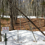
Known as pyramid tents or Scott tents, they’re essentially the same tent design used by the original polar explorers a hundred years ago, capable of withstanding winds of up to 70 miles per hour. “They’re just so good, they got the design perfect,” says the author. Image courtesy of Peter Davis.
Peter Davis of the British Antarctic Survey on changes in the Thwaites Glacier
By Dan Drollette Jr | May 1, 2020
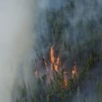
On the Thwaites Glacier on Antarctica’s western shelf, researchers are going all-out to learn what is happening deep under the surface of the ice, out of sight: How much is melting from below, where the ice comes into contact with warm ocean waters? Is the ice relatively solid throughout and resting solidly on the seabed, or is it about to slip off and dramatically raise the world’s sea levels?
To answer those questions, researchers have been landing on the leading edge of this glacier—a single mass of ice the size of Florida—and using all sorts of tools to peer beneath it. In this article, the Bulletin’s Dan Drollette Jr. interviews oceanographer Peter Davis of the British Antarctic Survey, freshly returned from several months in one of the coldest places on Earth. Davis explains how the very nature of Antarctica—the vast distances involved, the remoteness, the extremes of cold and wind, the physical demands on humans and equipment—affect the nature of the research in the field and gives a sense of the obstacles that must be overcome to get data on climate change from the front lines.
Davis also gives an informal account of some of the early trends they’ve been finding: huge amounts of ice sliding off into the sea, more ice melting at the so-called grounding zone where land meets sea, and the steady retreat of the grounding zone deeper inland. He also describes the effort involved in determining how much of this effect is due to natural variability, and how much is caused by human activities.

Dan Drollette: You just returned from Antarctica?
Peter Davis: We got back less than a week ago, on Sunday [February 9, 2020]. We were on the ice for three months—I went south in very early November. We were at base camp in McMurdo Sound, on the edge of the continent, for a month and then out in the field for two months, and then came home.
Drollette: It sounds very isolated. The BBC wrote that only four people have ever been on this glacier’s front edge—the place where the Thwaites Glacier meets the ocean water. Other publications say that only 28 people are known to have ever set foot on any part of this glacier. Were you completely cut off from civilization during that time?
Davis: We had a satellite communication system that allows very limited, text-based emails and some very small attachments. But otherwise, we had very limited contact. There’s no Skype, nothing like that.
Which makes for a kind of culture shock when you get back. It’s like “Crikey, everyone is running around like crazy, and really busy.” While you’ve gotten used to a small group of people and a very calm atmosphere.
You do feel kind of behind the news when you arrive home, catching up on what’s been going on—there was a whole election and a complete change of government while we were gone.
Drollette: If nothing else, I guess you can really focus on your work?
Davis: Right, there are no distractions. Which can actually be quite nice.
And besides, at the back of your mind is the idea that so much money has been spent on getting us there that we’d better do everything we possibly can in the time that we have. You’re just 100 percent focused on the job.
Drollette: You mentioned in passing that so much money is focused on getting folks down there. How much does it cost to send the expedition individual down to that region?
Davis: So the IT—or should we say the International Thwaites Glacier Collaboration—is a $50 million project. It’s a huge amount of money, for a five-year project involving a huge number of scientists, ships, and aircraft to study this region.
Drollette: Why so much interest in the Thwaites Glacier? Why spend all this money and time and labor?
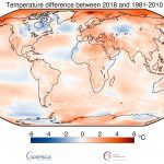
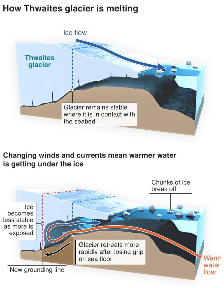
Davis: Fundamentally, we’re interested in trying to understand how Antarctica is going to contribute to future sea level rise. We want to really know how much it is going to contribute—and how quickly that contribution is going to happen. Antarctica is surrounded by ice shelves, which are kind of floating extensions of the ice sheet, and they act essentially as plugs that hold back the ice that’s grounded on the continent. The risk is that as those ice shelves melt and they begin to flow faster, you get more ice that’s on the land getting into the ocean, and that will cause sea levels to rise. (See figure below.)
So we’re particularly interested in Thwaites because it essentially drains a large portion of the West Antarctic ice sheet—it plugs a large area of grounded ice. And we know that the ice shelf is retreating, we know it’s melting, and we want to pin down why it’s doing it, how quickly it’s doing it, what can we expect from it in the future, and what this means for global sea level rise in the next century.
Drollette: I’ve heard different predictions as to how much sea level rise there would be if the Thwaites Glacier was to go. (Some publications have even used the phrase “doomsday glacier” to describe the current situation.) I don’t have the exact figure but I’ve heard anywhere from nine to 15 feet. What’s the general consensus?
Davis: My understanding is if the whole of the Thwaites Glacier were to collapse—and there’s no indication that would occur—you would get somewhere between 50 centimeters (19.5 inches) and maybe 65-to-80 centimeters (25.5-to-31.5 inches) of sea level rise from this one glacier and the region of the ice sheet that it drains alone.
But just to stress the point, there’s no indication that the whole of the glacier is going to collapse, no indication that that’s going to happen. That’s the potential, so that’s why we’re trying to understand: What sort of risk is associated with it.
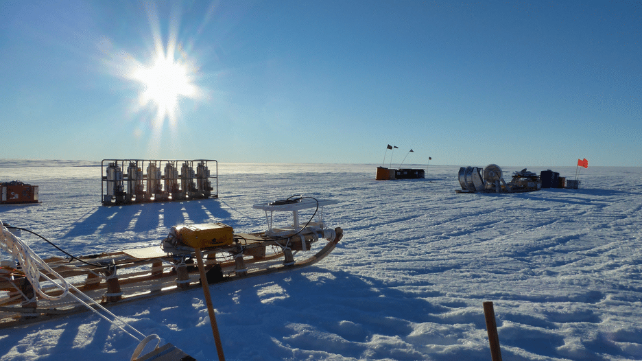
Image courtesy of Peter Davis
Drollette: So these other numbers must be referring to more than just the Thwaites Glacier alone collapsing—they must be in regard to all of the sea ice going?
Davis: The whole of the West Antarctic ice sheet, of which the Thwaites Glacier is a part, has the potential for two-to-three meters of sea level rise, if the whole of the ice sheet were to collapse. If that were to occur, it would be more of a thousand-year process, or certainly at least a hundred-year process.
So really what we’re doing is about trying to get some numbers and pin down what’s most likely, that can we go to a government with and say, this is our best estimate for the next hundred years, this is the challenge we need to fix.
Drollette: Okay. I know it’s early days, but can you tell us generally what you think is most likely to be happening? How much of Thwaites is likely to go and how quickly?
Davis: It’s very difficult to say so far, because essentially the way the project is set up to work is that we’ll do all of this field work, improve our understanding of the key process, take these observations and feed them into our best numerical models, and then we’ll use those numerical models to make a prediction over the next hundred years. So it’s very difficult to say right now how much we think is going to happen—at least for myself as somebody who’s doing the observations rather than the modeling.
The level of risk is what we want to understand. But I could not give you a figure right now.
Drollette: What about the ice itself? Is the ice at this part of the glacier relatively solid throughout, or kind of riddled with holes like a Swiss cheese?
Davis: Not so much Swiss cheese, as the ice will definitely be solid. Instead, what we’re concerned about is the point where the floating ice shelf touches the sea bed—where the ice goes afloat. We know that the processes at that point are really important, so we’ve been trying to understand how is the melting at that point controlled, and what sets the magnitude. And we’re also trying to understand how the ice moves over the bed at that point: Is it well-grounded, with solid contact with the seabed? Or is there water between the bed and the ice, a small amount that’s kind of lifting it off? And how vulnerable is that grounding zone to future melting?
The project I was involved in is trying to really understand these processes, that we can then feed into numerical models to make these future predictions.
The instruments are now out there, we’ve collected some data. We haven’t done much analysis, having only been back for about a week. So we’re basically going to start answering these questions and start trying to understand what’s going on.

Drollette: Can you tell us more about some of the tools that you’re using to accomplish this?
Davis: This international collaboration is made up of a large number of sub projects proposed by different UK and US scientists, and all of these tools are being used by a range of projects. We at the MELT project are focused on hot-water drilling.
Essentially, at the grounding zone you’ve got 600 meters (about 1,968 feet) of ice between you and the ocean, and we want to get to the ocean. That’s what we’re interested in. The quickest way to do that is to use a hot water drill, to essentially just drill an access hole straight down, as quickly as we possibly can. Once that access hole is open we can deploy stuff in the ocean, underneath the ice, and observe the conditions that we’re interested in.
But there are other projects more focused towards the ice front, even closer to the open ocean, should we say. They will be using ocean gliders—autonomous underwater vehicles—to swim under the ice, to understand how waters from the open ocean are getting under the ice shelf, to the source waters that eventually do the melting at the grounding zone.
Drollette: So essentially, folks are attacking this with different approaches? One is drilling down, more or less land-based, and seeing what’s at that crucial point where the ice is meeting the seabed. And the other is coming from the ocean side and getting into it there?
Davis: Right. And there’s a couple of ships at the moment that are working off Thwaites. The ships have a later season than the land-based stuff, because they don’t have to worry about getting flown in and out of there, so they’re much more capable of looking after themselves. They are down there at the moment doing the glider work, and taking sediment cores as well. It’s a multi-pronged multi-project, a huge collaboration at a very high level between the National Science Foundation in the US and the Natural Environment Research Council in the UK. They put out a call for proposals to come and do some science, \with a UK principal investigator and a US principal investigator on each project, these then sub-projects got put together. They include universities in the UK, universities in the US, and obviously the British Antarctic Survey as well.
So it’s multi-institution and multi-country—a huge international group of people.
Drollette: And now you’re back at Cambridge University?
Davis: I work for the British Antarctic Survey—a research center run by the Natural Environment Research Council. We don’t have any undergraduate teaching, we have post grad students here. So essentially my role is just an oceanographic researcher; I will work on the data that we’ve collected and publish papers on it and essentially work to understand how the glacier is changing and how it’s responding to the changing climate.
It’s funny, but I think there really had not been much interest by the media in what we were doing in Antarctica for a long time. It’s only in the last few years that there’s been interest by the press in this kind of Antarctic research and sea level rise, and the risks of climate change in the future. But that’s really changed, and I think the media is actually doing a really good job at the moment of raising awareness of these issues and the importance of trying to solve some of these problems.
Drollette: The press coverage I’ve seen says that the Thwaites Glacier is under threat. Is that an accurate way to describe the situation? I know you don’t have any publishable findings yet, but are you finding a general trend?
Davis: Yeah, I think that’s probably reasonable. What we’ve seen is that it’s definitely melting: The grounding zone is retreating. We see evidence that it’s retreated. We have taken a lot of observations that show the water is perfectly warm enough to melt the ice at the grounding zone.
So yeah, it’s definitely under threat. The question that we need to answer is how under threat is it? How much melting can it sustain before it collapses? And if it does start to collapse, how much will it collapse and how much will that cause sea levels to rise?
Drollette: And it’s not just confined to this one glacier in Antarctica?
Davis: No, definitely not. We’ve certainly seen on the Antarctic peninsula the entire collapse of two ice shelves: Larsen A and Larsen B.
Larsen C is still there, but a couple of years ago we saw that enormous iceberg calve from the front of it. We have no clear understanding of whether that is a natural phenomenon or that’s something caused by climate change, but it’s all part of this trend that we’re seeing of losing ice.
And then if we come around to the West Antarctic sector—the Amundsen Sea sector—the satellites show a huge loss of mass. So there’s been a huge amount of ice that has disappeared off the continent into the ocean. And that shows no sign of slowing down.
We’ve seen grounding lines retreat inland, and that’s the kind of precursor to some sort of collapse, as the grounding zone retreats and gets deeper and deeper inland.
So there is definitely a trend going on at the moment, whereby we’re losing ice and losing mass from the continent. The question we’re working on is, how much of that is natural variability, because undoubtedly that occurs, and how much of that is anthropogenic—as in climate change?
One of the key things that we do, alongside the oceanography, is take sediment samples from the seabed, because those sediment samples can recreate a history of the ice shelves and the ice sheet.
If we have a long history of how it’s evolved in the past, when there was no anthropogenic impact, we can begin to pick apart the changes we’re seeing today, and attribute them to whether it’s just natural variability, or completely outside the natural envelope.

Bathymetry courtesy of: Morlighem, M. 2019. MEaSUREs BedMachine Antarctica, Version 1. Boulder, Colorado USA. NASA National Snow and Ice Data Center Distributed Active Archive Center. doi: https://doi.org/10.5067/C2GFER6PTOS4.
Hillshade and contours: PGC. Howat, I. M., Porter, C., Smith, B. E., Noh, M.-J., and Morin, P.: The Reference Elevation Model of Antarctica, The Cryosphere, 13, 665-674, https://doi.org/10.5194/tc-13-665-2019.
Drollette: Why are scientists just getting around to this glacier now?
Davis: It’s a thousand miles from any research station—hugely far away. And it’s huge, it’s absolutely enormous. Just the Thwaites Glacier itself is the size of Florida.
And it’s taken a huge amount of time for countries to build the logistical know-how to get large amounts of equipment and fuel into these remote locations, and then be able to support the people there. With satellite communication nowadays it’s much easier to maintain a safety net over those sort of distances, as opposed to in the past, when those things didn’t exist. And back then you didn’t necessarily have planes capable of carrying that sort of equipment—or that sheer weight of equipment—that far into the deep field, and then recover people at the end of the season, whilst maintaining safety at all times.
And to do this stuff, everything has to line up just right. You don’t just turn up one year, do everything, and leave. There were people planning this five years ago, with equipment and fuel being brought in two or three years ago. It’s a multi-year, multi-stage process, and every single stage has to be completed successfully for the next one to occur. You can’t fly us in if you haven’t been able drag the fuel in a few years ago—and for the fuel to be in, the ship had to be able to get in, and for the ship to get in, that depends on where the sea ice is. So any sort of disruption to this massive logistics network can result in the science being delayed.
Drollette: It sounds like an old-fashioned assault on Mount Everest. They establish a base camp, build up things there, then use that to build a second camp farther up the mountain, and ferry enough things back-and-forth to be able to establish a third camp even higher, and then they’re finally able to make the attack on the top.
Davis: That’s exactly how it is. When we were there, there was a deep field camp called WAIS Divide, and then there was an intermediate camp called Lower Thwaites Glacier, and then there was the grounding zone. Kit was being flown between each of these camps, and planes were staging at different places. It was all scaling down as we went; as you got closer and closer to our site, it got smaller and smaller.
Which makes me have tremendous respect for what the old-time polar explorers did.
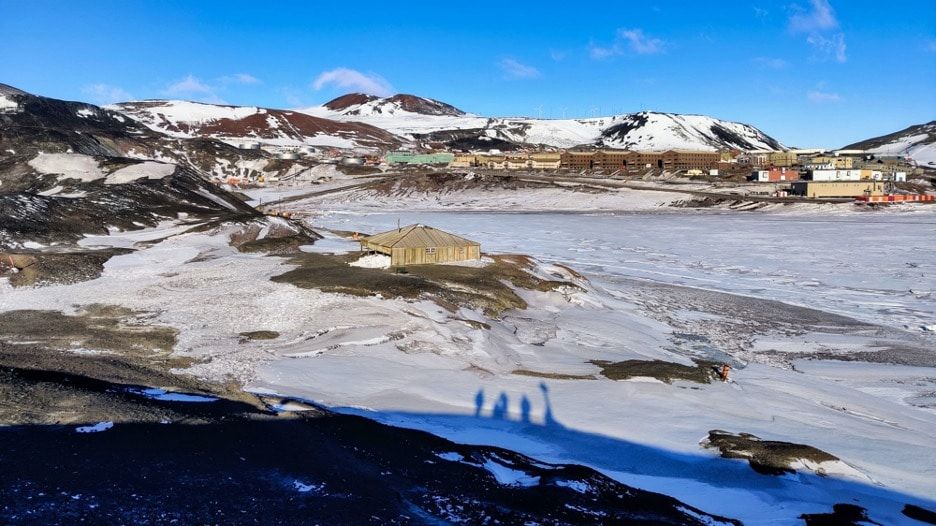
You can still stand in the middle of modern-day McMurdo Station and look across to one of Robert Falcon Scott’s wood huts—where he started out from in 1912 in the race to the South Pole. It’s a historic monument, and an incredible experience, to just stand there, look at the spot and think “we’re here, all very comfortable, with all the modern conveniences”—and then reflect on the conditions those guys must have had to put up with. It’s just indescribable.
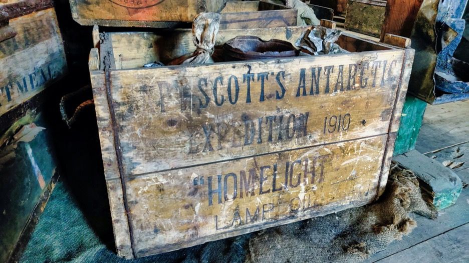
And it’s the original building. We were able to go inside and have a look around, and there’s the old biscuits, the old stoves, all manner of things hanging up, and old seal blubber that’s still there. You can definitely picture people being there—though it’s not as though it was completely abandoned overnight, or left at the last minute. They didn’t leave halfway through a meal, that is. But you can still imagine people being there, and you can smell the air and the soot that must have been produced in the seal blubber fires. It’s quite a thing.
They were so close to the limit of what the human body can put up with.
Even now, Antarctica can be quite demanding. On Thwaites, it was reasonably warm, because actually we were quite close to the ocean. So you’re kind of looking somewhere between -5 and -10 degrees Celsius most days (23 and 14 degrees Fahrenheit). But if you’re up on the polar plateau, or at the South pole, you’re at -20 or -30 Celsius (-4 or -22 degrees Fahrenheit), something like that.
And that’s in the summer. It’s much, much colder in the winter, of course.
Not to mention the wind. At Thwaites, we had one three-day storm, where the winds were blowing maybe 50 miles an hour. That was our only big storm, and fairly serious. With the weather forecasting technology today, you can see the storm coming and prepare the camp for it, so lots of flags were put out so that you could kind of follow the flag lines around as visibility gets terrible. Things were buttoned down, everything was kind of prepared. And then you basically sit it out for three days; you’re either in the mess tent or your personal tent, and you just wait for the storm to abate.
And when it’s over, you then spend a day or a day-and-a-half manually digging tons and tons and tons of snow out from all the equipment, such as the generators. Luckily, there were several of us there to share the work—10 scientists, two field guides, and a four-person media team from the BBC came down as well. So 17 of us actually. Lots of hands make light work, but it took a day of pretty much continuous digging to get everything unburied.
Drollette: What was the idea behind the use of flag-lines?
Davis: You can very easily get disoriented, because the white-out can just pop up at any time. Especially during the storms—the visibility comes and goes.
In really, really bad weather, you would definitely tell your tentmate where you’re going, what you’re doing, how long are you going to be. If you’re not going to be back, then they will come looking.
But actually your biggest friend is generally the wind, because the wind direction is usually very constant. You just need to picture where the wind is, and you use that to kind of navigate yourself around the camp, if the visibility is really that bad.
Drollette: You must burn a tremendous number of calories to do this research.
Davis: Definitely. I’ve never actually worked out the calories count but yeah, I know that for certain that as soon as I’m in the field, I eat almost twice as much as I do back in the UK. It’s a lot of hard manual labor—digging, and lifting heavy boxes. There’s no mechanical aids to help with that. And then you’re out in the cold, and your body is always keeping itself warm, so you burn probably thousands more calories than you would do at home.
So you just keep eating. And the thing to keep in mind is that all of this food is the result of those staging efforts, usually flown out or shipped out two or three years ahead of time. So it’s going to be stuff that has to be able to survive the cold, multiple winters, and then be eaten. So it’s going to be very basic: freeze-dried food that’s very military in style, plus plenty of snacks, nuts, chocolate, cheese, tinned meat, biscuits, and jam. And because it’s the UK, plenty of Marmite!
But on the Antarctic diet, you never have to worry about getting fat; you don’t have to think about what you’re eating. You just go out and work, and it all disappears.
Disclosure Statement
No potential conflict of interest was reported by the author.
Funding
This research received no specific grant from any funding agency in the public, commercial, or not-for-profit sectors.
Together, we make the world safer.
The Bulletin elevates expert voices above the noise. But as an independent nonprofit organization, our operations depend on the support of readers like you. Help us continue to deliver quality journalism that holds leaders accountable. Your support of our work at any level is important. In return, we promise our coverage will be understandable, influential, vigilant, solution-oriented, and fair-minded. Together we can make a difference.
Get alerts about this thread
0 Comments
Oldest

Dan Drollette Jr
Dan Drollette Jr is the executive editor of the Bulletin of the Atomic Scientists. He is a science writer/editor and foreign correspondent... Read More
ALSO IN THIS ISSUE